
Barefoot Science · Ecuador · Altitude · Biodiversity
Ecuador: Where the Equator Rises into the Andes
A Barefoot Science look at tropical altitude, microclimates, biodiversity, and food.
Ecuador is tropical, but not in the simple way.
When people hear the word “tropical,” they often imagine heat, beaches, palm trees, humidity, and endless summer. Ecuador has all of that, but it also has cold páramo, snow-covered volcanoes, spring-like cities, cloud forests, Amazon rivers, dry islands, and highland valleys where the air changes with every kilometer.
Ecuador is tropical because it sits on the Equator.
But Ecuador is extraordinary because altitude changes everything here.
It rises.
The tropical line rises into the Andes, crosses volcanoes and high valleys, descends into the Amazon Rainforest, touches the Pacific Coast, and reaches the Galápagos Islands. This is why Ecuador does not feel like one climate, one landscape, or one flavor. It feels like many worlds stacked vertically.
Pacific Coast
Warm currents, coastal foodways, marine life, cacao, mangroves, and tropical humidity.
Andes
Altitude, volcanoes, páramo, cool valleys, highland agriculture, and dramatic weather.
Cloud Forest
Mist, rain, hummingbirds, orchids, waterfalls, biodiversity, and constant transition.
Amazon Rainforest
Rivers, humidity, rainforest life, medicinal plants, yuca, wildlife, and deep ecological memory.
In Ecuador, tropical does not only mean hot.
It means sun, altitude, rain, clouds, rivers, volcanoes, ocean currents, forests, food, and constant movement.
It is tropical like water: always changing shape.
1. The Equator is not the whole story
The Equator gives Ecuador one of its most important natural conditions: strong and relatively consistent solar energy throughout the year. This helps explain why the country does not have four classic seasons like northern Europe or North America.
But latitude alone does not explain Ecuador.
Many countries are crossed by the Equator. Some are dominated by rainforest. Others by islands, savannas, drylands, or ocean. Ecuador is different because the Equator crosses one of the world’s great mountain systems: the Andes.
That single fact changes everything.
The Andes lift the tropics into altitude. As elevation increases, the air becomes cooler. This creates dramatic climate changes over short distances. A traveler can move from warm coastal lowlands to cool highland valleys, from páramo to cloud forest, or from Andean slopes into humid Amazon rainforest in a single day.
This is the science behind Ecuador’s feeling of constant transition.
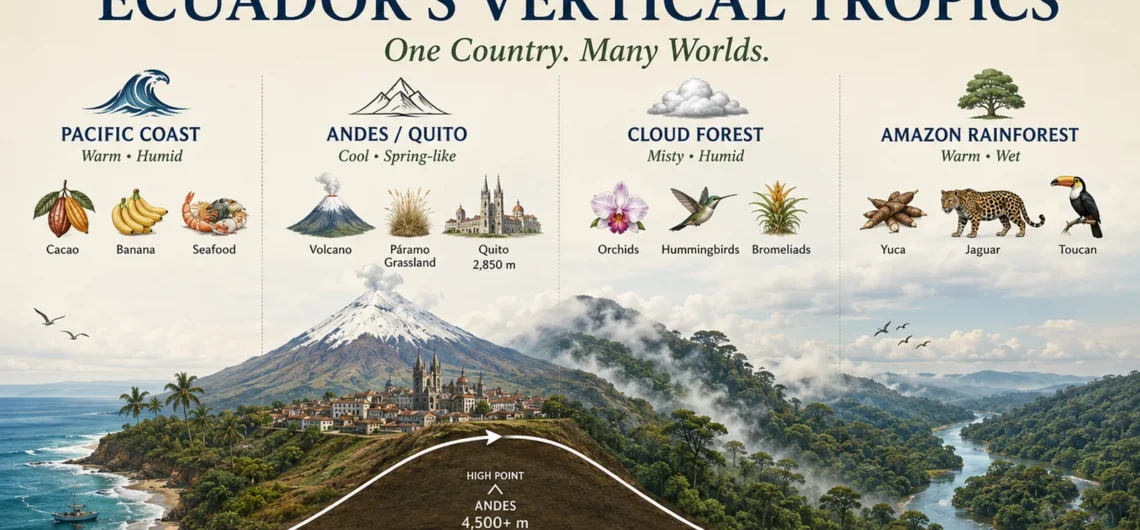
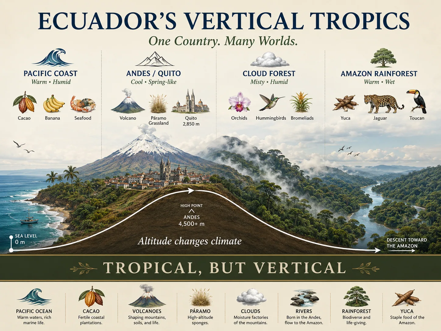
Graphic 1: Ecuador’s Vertical Tropics
Pacific Coast          Andes / Quito              Amazon Basin
Sea level              2,000–4,000 m+             Lowland rainforest
Warm / humid           Cool / spring-like          Warm / wet
Cacao, banana          Potato, corn, grains        Yuca, plantain, guayusa
Mangroves              Páramo, valleys             Rivers, forest, wildlife
        → altitude rises → climate cools → water flows → life changes
2. Tropical altitude: the hidden key
Ecuador’s climate is shaped by a simple but powerful scientific rule: temperature decreases with altitude.
That is why Quito, even though it is near the Equator, does not feel like a hot tropical city. It feels like an elevated tropical spring. The light is strong, the sky can be intensely blue, palms can grow in the city, but the air remains fresh because Quito sits high in the Andes.
This is one of Ecuador’s most beautiful contradictions:
A tropical country where you may need a jacket.
A mountain city with palms.
A place where rain and sun can appear on the same afternoon.
A country where “summer” and “winter” are less important than altitude, wind, clouds, and region.
Ecuador is not cold because it is far from the Equator.
It is cool because the tropics have been lifted into the mountains.
Table 1: Why Ecuador feels different from many equatorial countries
| Factor | In many equatorial countries | In Ecuador |
|---|---|---|
| Latitude | Strong tropical sunlight | Strong tropical sunlight |
| Altitude | Often lowland-dominant | Extreme altitude changes in short distances |
| Climate | Often hot, humid, rainforest, savanna, or island-based | Coast, Andes, Amazon, Galápagos, cloud forest, páramo |
| Travel experience | Large regions may feel climatically similar | Climate can change dramatically in a few hours |
| Food systems | Tropical crops dominate many areas | Tropical, Andean, Amazonian, coastal, and island food systems coexist |
| Identity | Tropical lowland or island identity | Vertical tropical identity |
3. Ecuador is a country of microclimates
A microclimate is a local climate pattern influenced by geography: altitude, slope, wind, rainfall, vegetation, water, and exposure to the sun.
Ecuador has thousands of microclimate expressions because the land is folded, elevated, broken, and connected by water. A valley can be dry while a nearby slope is covered in cloud forest. A high plateau can be cold while a lower basin produces tropical fruit. One side of the Andes may receive Amazonian moisture while another faces Pacific influence.
This is why Ecuador feels so alive.
It is not one tropical climate.
It is a system of tropical climates.

The Andes act like a great climatic engine. They intercept air masses, create rain shadows, guide rivers, form valleys, and divide the country into ecological layers. Water moves from glaciers and páramo wetlands into rivers, farms, forests, and communities.
In Ecuador, climate is not background.
Climate is architecture.
Graphic 2: The Microclimate Engine
SUNLIGHT
   ↓
EQUATORIAL ENERGY
   ↓
ANDES MOUNTAINS
   ↓
Altitude + Slope + Clouds + Rain + Wind
   ↓
MICROCLIMATES
   ↓
Biodiversity + Agriculture + Food + Culture
4. Ecuador’s four natural worlds
Ecuador is often described through four major natural regions: the Pacific Coast, the Andes, the Amazon, and the Galápagos Islands. Each region has its own climate logic, landscapes, species, ingredients, and human history.
Together, they form one of the most compact natural laboratories on Earth.
Table 2: Ecuador’s four natural worlds
| Region | Climate character | Scientific driver | Food and cultural expression |
| Coast | Warm, tropical, humid or seasonally dry | Pacific influence, low elevation, ocean currents | Cacao, banana, seafood, plantain, rice, tropical fruits |
| Andes | Cool, variable, spring-like to cold | Altitude, volcanoes, valleys, páramo | Potato, corn, quinoa, beans, cheese, soups, grains |
| Amazon | Warm, humid, rainy, river-based | Rainforest, rivers, eastern Andean slopes | Yuca, plantain, guayusa, fish, cacao, medicinal plants |
| Galápagos | Dry to humid island zones | Ocean currents, volcanic islands, elevation | Seafood, island agriculture, conservation-based travel |
5. Biodiversity: life stacked by altitude
Ecuador’s biodiversity is not an accident. It is the result of geography.
The country sits in the tropics, where solar energy supports intense biological productivity. But it also has mountains, ocean currents, forests, islands, and river systems. These forces create many habitats in a small space.
Species do not live everywhere equally. Some belong to the dry coast. Some belong to cloud forests. Some live only in páramo. Some are found in Amazon wetlands. Some evolved uniquely in the Galápagos Islands.
In Ecuador, biodiversity is stacked vertically.

The country is small, but its ecological layers are immense. This is why a journey through Ecuador can feel like crossing continents without leaving one country.
Graphic 3: Biodiversity by Elevation
High Andes / Páramo
Condors, grasslands, wetlands, volcano ecosystems
        ↓
Cloud Forest
Hummingbirds, orchids, spectacled bears, mist forests
        ↓
Inter-Andean Valleys
Agriculture, human settlements, dry valleys, cultural landscapes
        ↓
Amazon Rainforest
Monkeys, macaws, river dolphins, giant trees, amphibians
        ↓
Pacific Coast / Galápagos
Marine life, mangroves, seabirds, reptiles, island endemism
6. Food is climate you can taste
Ecuadorian food is one of the best ways to understand the country’s geography.
Every ingredient carries altitude.
Potatoes, mellocos, corn, grains, and cheese speak of the Andes. Yuca, plantain, guayusa, cacao, and river fish speak of the Amazon. Seafood, coconut, rice, peanut, banana, and tropical fruits speak of the Coast. Galápagos adds the ocean, islands, volcanic soil, and conservation awareness.

This is why Ecuadorian cuisine is so diverse. It is not only a cultural mixture. It is a climatic map.
A soup in the highlands is not just a soup. It is altitude, family, cold mornings, markets, and volcanic soil.
A coastal dish is not just seafood. It is ocean current, mangrove, humidity, port culture, and tropical abundance.
Amazon food is not only rainforest cuisine. It is river knowledge, plants, community memory, and the deep relationship between people and forest.
Ecuador’s food diversity exists because Ecuador’s climate diversity exists.
Table 3: Ecuadorian food as a climate map
| Altitude / Region | Landscape | Ingredients | Food identity |
| High Andes | Páramo, valleys, volcano slopes | Potato, corn, grains, beans, cheese, herbs | Soups, stews, roasted grains, highland markets |
| Cloud Forest | Moist mountain slopes | Fruits, coffee, sugarcane, herbs | Fresh juices, panela, local harvests |
| Amazon | Rainforest and rivers | Yuca, plantain, fish, guayusa, cacao | Community cooking, river food, medicinal plants |
| Coast | Lowlands, mangroves, ocean | Seafood, rice, peanut, coconut, plantain | Ceviche, encocados, encebollado, coastal soups |
| Galápagos | Volcanic islands and sea | Fish, local produce, marine influence | Island cuisine shaped by conservation and isolation |
7. Why the sun feels different here
Anyone who has spent winter in northern Europe understands the emotional power of sunlight.
In places like Germany, winter light can be low, grey, and brief. The body notices. The mood notices. The sky feels far away.
In Ecuador, the sun returns constantly. Even on rainy days, light often breaks through. In Quito, the blue sky after rain can feel almost unreal. The air is fresh, the sun is strong, and the mountains hold the clouds like moving architecture.
This is not only romantic. It is geographic.
Near the Equator, daylight remains relatively stable through the year. Ecuador does not lose the sun in the same seasonal way that northern countries do. The rhythm is different. Instead of long winter darkness and long summer daylight, Ecuador lives through daily movement: morning sun, afternoon clouds, sudden rain, clear skies, cold nights, warm valleys.
The drama is not seasonal.
The drama is daily.
8. Ecuador compared with the Equator line
The Equator crosses several countries around the world. But each one expresses the Equator differently.
In Brazil, the Equator touches the vast Amazonian lowlands.
In Central Africa, it crosses major rainforest systems.
In Indonesia, it passes through island tropics and volcanic landscapes.
In Kenya and Uganda, altitude also shapes equatorial climates.
In Somalia, the Equator touches drylands and hot coastal regions.

Ecuador belongs to this global equatorial family, but it has a unique identity because so many worlds are compressed into such a small territory.
The country combines tropical latitude, Andean altitude, Amazonian moisture, Pacific influence, and Galápagos oceanic isolation.
That combination is rare.
Ecuador is not the largest equatorial country.
It is not the hottest.
It is not the flattest.
It is not only rainforest, island, savanna, or coast.
Ecuador is vertical.
That is its signature.
Table 4: Ecuador and other equatorial landscapes
| Equatorial expression | Countries / regions where it appears | Ecuador’s version |
| Lowland rainforest | Brazil, Congo Basin, Indonesia | Amazon Rainforest in the east |
| Equatorial highlands | Kenya, Uganda, Colombia, Ecuador | Andes crossing the Equator |
| Island tropics | Indonesia, São Tomé and Príncipe, Maldives, Kiribati | Galápagos Islands with volcanic and ocean-current influence |
| Dry equatorial zones | Somalia, parts of Kenya | Dry valleys, dry coast, and dry Galápagos zones |
| Compact multi-region diversity | Rare | Coast, Andes, Amazon, Galápagos in one small country |
9. The Barefoot Science idea
To understand Ecuador, you have to stop thinking horizontally.
Most maps make us think from left to right: coast, mountains, jungle, islands. But Ecuador must also be understood vertically.
Every meter of altitude changes temperature.
Every slope changes rainfall.
Every valley changes agriculture.
Every river connects one ecosystem to another.
Every region gives a different flavor.
This is why Ecuador is such a powerful country for nature-based travel. It is not only beautiful. It is readable. The landscape teaches.
A traveler can learn geology from volcanoes, climate from clouds, biology from hummingbirds, food history from markets, and human adaptation from communities living at different elevations.
This is the Barefoot way to see Ecuador:
Not only as a destination, but as a living system.
10. Final reflection: tropical like water
Ecuador is tropical, yes.
But it is not only hot tropical.
It is mountain tropical.
Cloud forest tropical.
Amazon tropical.
Pacific tropical.
Island tropical.
Cold morning tropical.
Blue sky tropical.
Palm trees in Quito tropical.
It is tropical with altitude.
That is why the country feels impossible to reduce to one image. A volcano can hold snow above a valley full of flowers. A city can have palms and cold nights. A market can sell potatoes from the highlands beside fruits from warm valleys. A river can begin in the páramo and end in the Amazon.
Ecuador is not one climate.
It is movement.
It is water falling from mountains, clouds forming over forests, sunlight returning after rain, and food growing from every layer of the earth.
Ecuador is where the Equator rises into the Andes.
And from that rise, a whole country of life begins.
Barefoot Science Journeys
Travel Like Water Through Ecuador
Ecuador is not one landscape — it is a living system of coast, Andes, cloud forest, Amazon, and islands. Move through it with local knowledge, scientific curiosity, and the freedom to follow the rhythm of the land.
Barefoot Expeditions designs private Ecuador journeys shaped by altitude, weather, wildlife, culture, and time — carefully planned from the ground up.
Start Planning Your Journey